Visayas

Fast facts
- Official language
- Visayan languages
- Population
- 21,155,014
Facts from Wikipedia’s “Visayas” page (CC BY-SA 4.0).
The Visayas or Visayan Islands (Cebuano and Wáray-Wáray: Kabisay-an, Tagalog: Kabisayaan, Spanich: Bisayas), is one of the three principal geographical divisions of the Philippines; the other two divisions are Mindanao, to the south, and Luzon, to the north.
People living in this islands are called Visayans.
Geography
The Visayas consists of several islands in central Philippines around the Visayan Sea, with the Philippine Sea to the east and the Sulu Sea to the west.
The main islands (and area) are:
- Bohol, 3,269 km² (1,262 sq mi)
- Cebu, 4,468 km² (1,725 sq mi)
- Leyte, 7367.6 km² (2,844.6 sq mi)
- Negros, 13328.4 km² (5,146.12 sq mi)
- Panay, 12,011 km² (4,637.5 sq mi)
- Samar, 12,849 km² (4,961 sq mi)
Regions and provinces
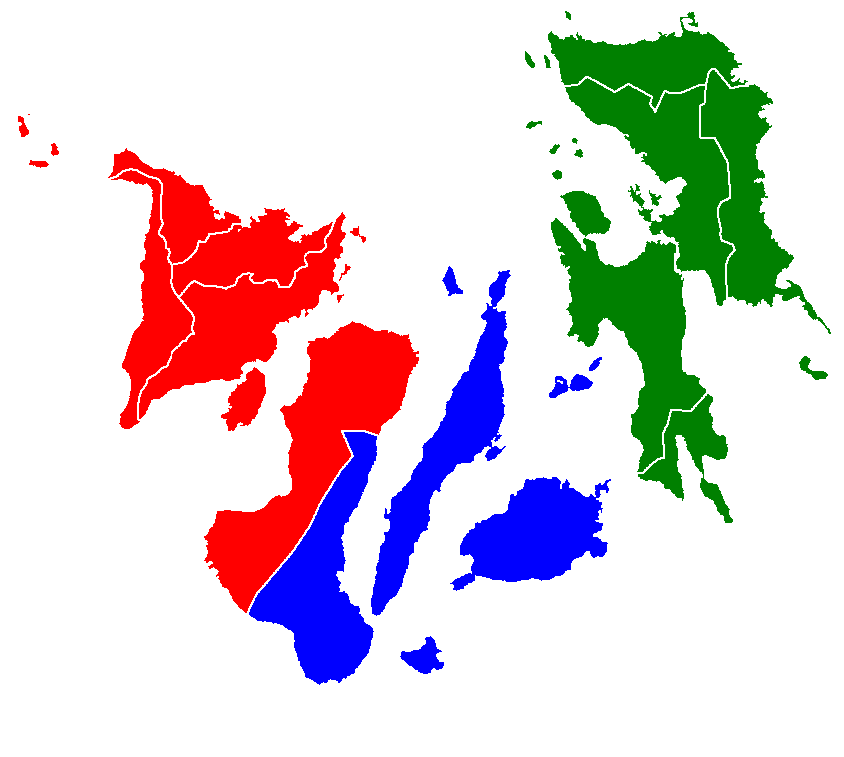
Administratively, the Visayas is divided into 3 regions: Western Visayas, Central Visayas and Eastern Visayas. Each region is headed by a Regional Director.
List of provinces of Visayas state
The Visayas is composed of 16 provinces, each headed by a governor.
Western Visayas (Region VI)
Western Visayas consists of the islands of Panay and the western half of Negros; it has a population, in 2010, of 7,102,438. The regional center is Iloilo City.
Central Visayas (Region VII)
Central Visayas includes the islands of Cebu and Bohol and the eastern half of Negros; it has a population, in 2010, of 6,800,180. The regional center is Cebu City.
Eastern Visayas (Region VIII)
Eastern Visayas consists of the islands of Leyte and Samar; it has a population, in 2010, of 4,101,322. The regional center is Tacloban.
Where this page comes from
The article above is adapted from “Visayas” on Simple English Wikipedia, by its contributors. We removed reference markers, navigation boxes and tables, expanded measurement templates into readable numbers, and kept the prose otherwise intact.
Both sources are published under CC BY-SA 4.0, so this page is published under the same licence. You may share and adapt it, including commercially, as long as you credit the original and keep the same licence.
Worksheets, answer keys and printable layouts elsewhere on K5Print are our own work and are not covered by this licence.