French Guiana
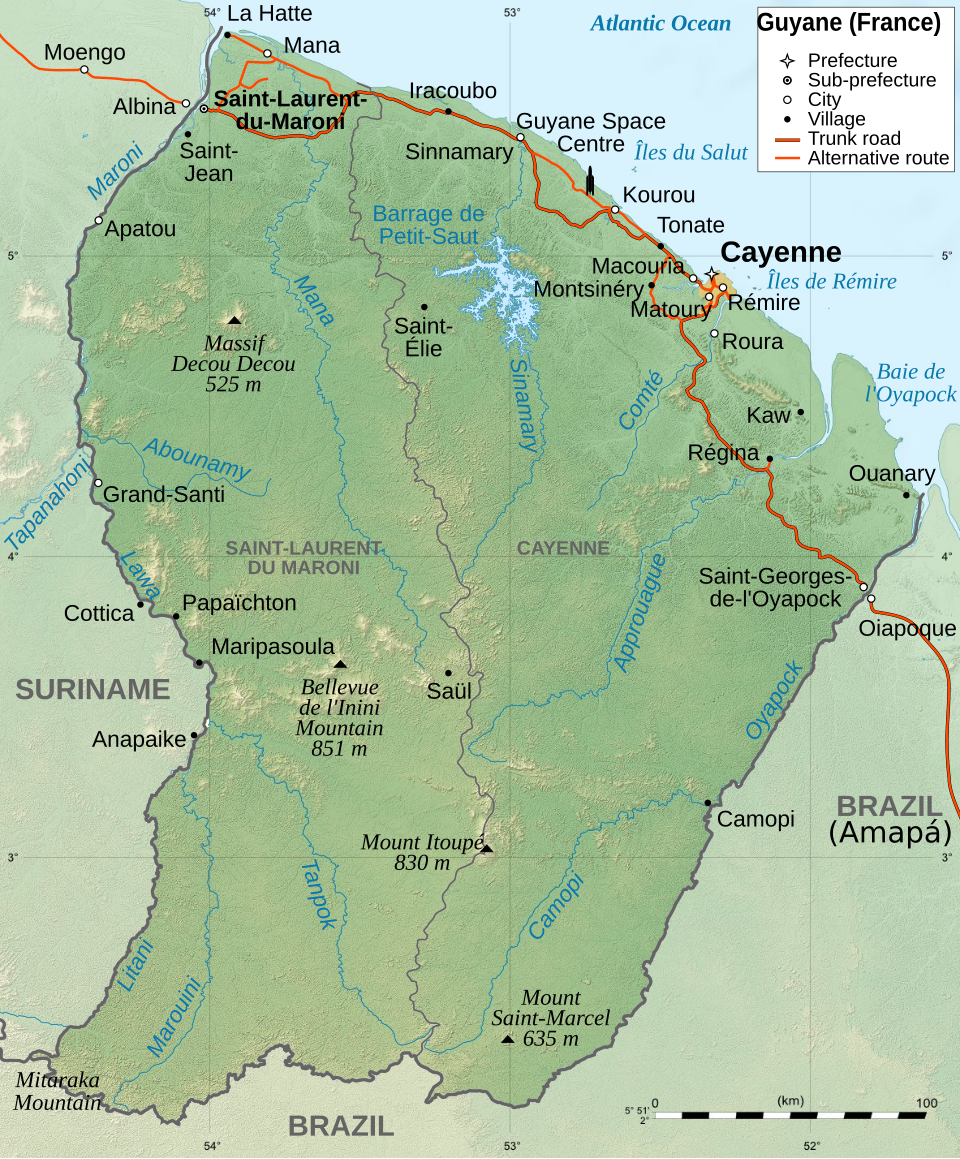

French Guiana () is an overseas department and region of France, on the north Atlantic coast of South America. By land area, it is the second largest region of France (after Nouvelle-Aquitaine) and the largest overseas department of France and of the European Union.
Its prefecture and largest city is Cayenne.
Name
Guiana comes from an Amerindian language (Arawak) that means “land of many waters”. The addition of the word “French” in most languages other than French comes from colonial times when there were five in the region; they were, from west to east:
- Spanish Guiana (now Guayana Region in Venezuela)
- British Guiana (now Guyana)
- Dutch Guiana, (now Suriname)
- French Guiana (now Guyane)
- Portuguese Guiana (now Amapá in Brazil).
French Guiana and the two larger countries to the north and west, Guyana and Suriname, are still often collectively referred to as the Guianas and form the Guiana Shield.
Geography
French Guiana borders two countries: Surinam to the west, and Brazil to the east and south. To the north is the Atlantic Ocean. There are two main geographical regions: a coastal strip where the majority of the people live, and a dense rainforest which gradually rises to the modest peaks of the Tumuc-Humac mountains along the Brazilian frontier.
The highest point in the department is Bellevue de l’Inini Bellevue de l’Inini in the Maripasoula commune; it is (851 metres (2,790 ft)) high. Other mountains are Mont Machalou (782 metres (2,570 ft)), Pic Coudreau (711 metres (2,330 ft)) and Mont St Marcel (635 metres (2,080 ft)).
Several small islands are found off the coast, the three Îles du Salut which include Devil’s Island, and the isolated Îles du Connétable further along the coast towards Brazil.
The Petit-Saut Dam in the north of the department forms an artificial lake and provides hydroelectricity. There are many rivers in French Guiana.
It is the French department with more forests, 98% of the department is covered with an equatorial forest.
2007, the Amazon rainforest in the most southern part of the department, is protected as the Guiana Amazonian Park, one of the ten national parks of France. The territory of the park covers some 33,900 square kilometres (13,089 sq mi) in the communes of Camopi, Maripasoula, Papaïchton, Saint-Élie and Saül.
Climate
The climate in Cayenne, at an altitude of 9 metres (30 ft) above sea level, is of the subtype Af (Tropical Rainforest Climate also known as Equatorial Climate) in the Köppen climate classification.
The average temperature for the year in Cayenne is 26.7 degrees Celsius (26.7 °F). The warmest month, on average, is September with an average temperature of 27.2 degrees Celsius (27.2 °F). The coolest month on average is January, with an average temperature of 26.1 degrees Celsius (26.1 °F).
The average amount of precipitation for the year in Cayenne is 3205.5 millimetres (126.2 in). The month with the most precipitation on average is May with 513.1 millimetres (20.2 in) of precipitation. The month with the least precipitation on average is September with an average of 43.2 millimetres (1.7 in). There is an average of 201.0 days of precipitation, with the most precipitation occurring in May with 27.0 days and the least precipitation occurring in September with 5.0 days.
Administration
The department of French Guiana is managed by the Collectivité territorial de la Guyane in Cayenne.
Administrative divisions
There are 2 arrondissements (districts) and 22 communes (municipalities) in French Guiana. The cantons of the department were eliminated on 31 December 2015 by the Law 2011-884 of 27 July 2011.
The 22 communes in the department are:
Demographics
The inhabitants of French Guiana are known, in French, as Guyanais (women: Guyanaises).
French Guiana has a population, in 2014, of 252,338, for a population density of inhabitants/km 2 . The city with more people living in it is the capital, Cayenne (55,817 inhabitants). The subprefecture of Saint-Laurent-du-Maroni has 44,169 inhabitants.
Evolution of the population in French Guiana Colors= id:lightgrey value:gray(0.9) id:darkgrey value:gray(0.7) id:sfondo value:rgb(1,1,1) id:barra value:rgb(0.6,0.7,0.8)
ImageSize = width:500 height:373 PlotArea = left:50 bottom:30 top:30 right:30 DateFormat = x.y Period = from:0 till:275000 TimeAxis = orientation:vertical AlignBars = justify ScaleMajor = gridcolor:darkgrey increment:50000 start:0 ScaleMinor = gridcolor:lightgrey increment:25000 start:0 BackgroundColors = canvas:sfondo
BarData= bar:1967 text:1967 bar:1974 text:1974 bar:1982 text:1982 bar:1990 text:1990 bar:1999 text:1999 bar:2008 text:2008 bar:2014 text:2014
PlotData= color:barra width:30 align:left
bar:1967 from:0 till: 44392 bar:1974 from:0 till: 55125 bar:1982 from:0 till: 73022 bar:1990 from:0 till: 114678 bar:1999 from:0 till: 157213 bar:2008 from:0 till: 219266 bar:2014 from:0 till: 252338
PlotData= bar:1967 at: 44392 fontsize:S text: 44,392 shift:(-12,5) bar:1974 at: 55125 fontsize:S text: 55,125 shift:(-18,5) bar:1982 at: 73022 fontsize:S text: 73,022 shift:(-18,5) bar:1990 at: 114678 fontsize:S text: 114,678 shift:(-18,5) bar:1999 at: 157213 fontsize:S text: 157,213 shift:(-18,5) bar:2008 at: 219266 fontsize:S text: 219,266 shift:(-18,5) bar:2014 at: 252338 fontsize:S text: 252,338 shift:(-18,5)
Economy
The main traditional industries are fishing, gold mining and timber. The Guiana Space Centre of the European Space Agency has played a significant role in the local economy since it was established in Kourou in 1964.
Devils Island Prison
Three Islands off the coast were used by the French Government from 1852 to 1953 as Prison Islands. They were:
- Royale Island
- Saint-Joseph Island used for solitary confinement in silence and darkness for escape attempts
- Devils Island for political prisoners [Dreyfus was kept here] Convicts who were sentenced to more than 8 years and survived and served their terms could not return to France but were required to stay on as involunatary settlers for the rest of their lives. Famous Inmates:
- Alfred Dreyfus
- Henri Charrière [b.16 November 1906-d.19 July 1973] aka Papillion (Butterfly). A Burglar and safe cracker he was convicted 26 October 1931 of the Murder of a pimp named Roland Le Petit [ He admitted being a criminal but denied the murder charge]. He was sentenced to life in prison and ten years of hard labour. He married Georgette Fourel, mayor of the 1st arrondissement of Paris, on December 22, 1931. [They divorced on 8 July 1970 by decision of the Paris High Court]. After a brief imprisonment at the transit prison of Beaulieu in Caen, France, he was transported in 1933 to the prison of St-Laurent-du-Maroni on the Maroni River, in the penal settlement of mainland French Guiana. He claimed to have engaged several escapes from 1933 to 1941 when he finally succeeded in escaping. In 1942 he was arrested and sent to a brutal penal settlement in El Dorado, Bolivar State, Venezuela. After a year of imprisonment, Charrière was released with identity papers on 3 July 1944. Five years later he was given Venezuelan citizenship; he became a businessman and married again. His 1969 autobiography became a best selling book and later made into a movie with Steve McQueen and Dustin Hoffman. French records of his life from 1933 to 1944 present a different account: He left the citadel of Saint-Martin-de-Ré on 29 September 1933 aboard the Martinière and landed on 14 October with the status of “transported” to Saint-Laurent-du-Maroni. There is little time left in the transportation camp as he is assigned as a nursing assistant to the André-Bouron Colonial Hospital, where he sees many inmates returning from the run and tell him their escape stories from which he will draw inspiration. This place prevents him from the work of logging sites or agricultural concessions that annihilate convicts in a few months. He escaped for the first time on September 5, 1934, but failed in Colombia, a country that returned escaped convicts to France. Judging by the Special Maritime Court, he spent two years in the cells of the St. Joseph’s Island Seclusion. Several times transferred, he ended up as a nurse-chief in an Indochinese camp on the Guyanese mainland, the Cascades forest camp from which he escaped on the night of March 18-19, 1944, along with four other companions.]
Written for younger readers
French Guiana, in simpler words
This version comes from Wikijunior, a set of books written for children aged 8 to 11. It is shorter and uses plainer language than the article above.
From Wikijunior: South America
Part of Wikijunior South America project
French Guiana is an overseas department of France, on the northern coast of South America. Like metropolitan France, its currency is the euro.
French Guiana was originally inhabited by a number of American peoples. It was settled by the French in the 17th century. A border dispute with Brazil occurred in the late 19th century over a large area of the jungle. This dispute caused the French Guiana to be an independent state until it could be resolved. In 1946, French Guiana became an overseas department of France. In the 1970s Hmong refugees came from Laos and settled in. In the 1970s and 1980s there became an increase of French people moving to settle in the area.
The French Guiana area is tropical and is usually hot and humid with a total area of 91,000 square kilometres. There is little seasonal temperature difference with dry summers and rainy winters. French Guiana’s population is around 209,000, most of whom live along the coastal region. Much of French Guiana is a national park.
- Guiana Space Centre – an important ESA spaceport.
- Guiana Amazonian Park – the largest park and rainforest in the EU.
Where this page comes from
The article above is adapted from “French Guiana” on Simple English Wikipedia, by its contributors. We removed reference markers, navigation boxes and tables, expanded measurement templates into readable numbers, and kept the prose otherwise intact. The simpler version is adapted from Wikijunior on Wikibooks.
Both sources are published under CC BY-SA 4.0, so this page is published under the same licence. You may share and adapt it, including commercially, as long as you credit the original and keep the same licence.
Worksheets, answer keys and printable layouts elsewhere on K5Print are our own work and are not covered by this licence.