Slovakia

Fast facts
- Official language
- Slovak
- Capital
- Bratislava
- Population
- XX
- Currency
- Euro (€) 2
- Time zone
- CET
- Drives on
- right
- Calling code
- +421 4
Facts from Wikipedia’s “Slovakia” page (CC BY-SA 4.0).
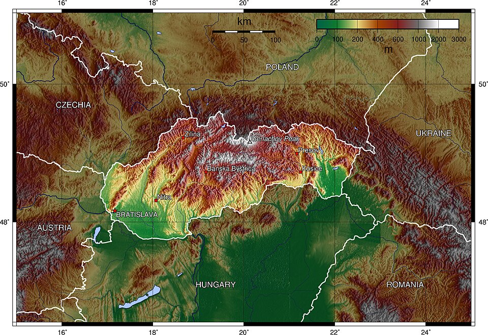
Slovakia (Slovak: Slovensko) (Official name The Slovak Republic, Slovenská republika) is a landlocked country in the eastern region of Central Europe. It is bordered by Austria in the southwest, Hungary in the south, Ukraine in the east, Poland in the north and Czech Republic in the northwest. Its capital city is Bratislava, the only capital of the world that borders with other two countries. Other main cities are Košice, Prešov, Žilina, Banská Bystrica, Trenčín, Nitra and Trnava. Slovakia has been a member of the European Union since 2004 and its official currency is the Euro.
History
The Celts started to settle since 450 BC. The coins named Biatec represent the first use of writing in Slovakia. After the time of the Julio-Claudian dynasty many different Germanic tribes like Quadi and Marcomanni started to overtake the area. The Roman Empire established many outposts along the Danube river. They fought Germanic tribes, with the most northern presence being in Trenčín (Laugaritio), during the Marcomannic Wars.
Great Moravia was at first in constant quarrels with East Francia and at the beginning of the 10th century, with the Magyars who arrived from Asia. The Magyars conquered Great Moravia in 906, and established the Hungarian Principality, resulting later in the creation of the Kingdom of Hungary in year 1000. Slovaks continued to live in the north, while most Hungarians were in the south.
A huge population loss resulted from the Mongol invasions in 1241. The Hungarian kings started to invite other settlers, for example Germans in the 13th century, and many others started to arrive in the kingdom, Vlachs from Romania in the 14th century and Jews.
In the 16th century the Ottoman Empire occupied the southern part of the kingdom including the two most important towns, Buda (capital) and Székesfehérvár (coronation capital). Many Hungarian nobles moved to Slovakia and the king moved to Bratislava (Pressburg, Pozsony at that time). The wars against the Ottomans and an uprising against the Habsburg s caused much destruction. After the Ottomans started to retreat back from Hungary, Bratislava continued to be capital until 1848, when it was moved back to Budapest.
The creation of a dual monarchy, Austria-Hungary, enabled the Hungarian government to initiate a policy of suppressing the teaching of languages other than the Hungarian language in state schools. The official use of other languages than Hungarian was also discouraged. During this time, a nationalist movement arose among Slovakians. A part of this movement joined forces with a part of the Czech nationalist movement. During World War I, this movement convinced the future victorious powers to recognise a new state of Czechoslovakia after the war.
The territory of today’s Slovakia was a part of Czechoslovakia from 1918 to 1938 and again from 1945 until 1989. Czechoslovakia was one of the states which came into existence after the breakup of Austria-Hungary at end of World War I in 1918. Czechoslovakia split up in 1939, when Slovakia, under Hitler’s influence and pressure, declared independence and became a client state. The state existed during World War II. It was a totalitarian one-party state and ally of Nazi Germany. Under the regime, the state fought in the war on the side of Nazi Germany and deported about 70,000 of its Jewish citizens to Nazi extermination camps as part of the Holocaust.
The territory of Czechoslovakia was liberated by the Soviet Union at the end of World War II in 1945. After the liberation, Czechoslovakia was reunified and briefly existed as a democratic country. The Communist Party successfully performed a state coup in 1948 and ruled Czechoslovakia as a totalitarian one-party state which was a satellite of the Soviet Union. In 1989, the one-party rule of the Communist Party was overthrown during the Velvet Revolution, which was a series of large and peaceful demonstrations by the citizens in the streets.
Czechoslovakia again became a democratic country. However, it split up into two independent countries (Slovakia and Czech Republic) on January 1, 1993 when it became an independent country. Slovakia has been a member of the European Union since May 1, 2004.
Geography
Slovakia is landlocked. It is noted primarily for its mountainous nature, with the Carpathian Mountains being in the north and various lowlands mostly in the south. The highest mountain range are the Tatra mountains with the highest peak, the Gerlachov Peak (Slovak: Gerlachovský štít; 2,654 m). Major Slovak rivers besides the Danube are the Váh and Hron.
At low altitudes, Slovakia’s climate is humid continental (Dfb in the Koeppen climate classification, with warm summers and cloudy, cold and humid winters. At high altitudes it is subarctic and alpine.
Transport
- Rail: Slovakia has 3,662 km of rails, of which 3,512 km are in standard gauge. Rail network currently undergoes a modernisation.
- Road: Slovakia has 42,993 km of roads, of which 316 km are motorways (2003). The motorway network is currently under construction.
- Air: Slovakia has 6 international airports, with the most important ones being in Bratislava and Košice, others are near Sliač, Poprad, Žilina and Piešťany.
- Marine: Slovakia has no direct access to the sea. The most important waterway is the Danube, with the ports in Bratislava and Komárno. The Danube and the Rhine-Main-Danube canal connects Slovakia to the North Sea and the Black Sea.
Administrative division
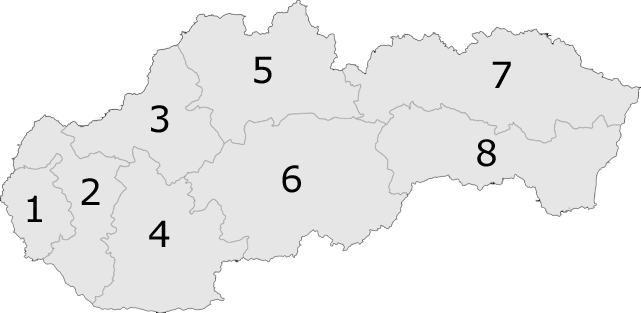
There are currently 8 regions of Slovakia:
- Bratislava Region (Bratislavský kraj) (capital Bratislava)
- Trnava Region (Trnavský kraj) (capital Trnava)
- Trenčín Region (Trenčiansky kraj) (capital Trenčín)
- Nitra Region (Nitriansky kraj) (capital Nitra)
- Žilina Region (Žilinský kraj) (capital Žilina)
- Banská Bystrica Region (Banskobystrický kraj) (capital Banská Bystrica)
- Prešov Region (Prešovský kraj) (capital Prešov)
- Košice Region (Košický kraj) (capital Košice)
These are further divided into many districts. There are currently 79 districts of Slovakia.
Written for younger readers
Slovakia, in simpler words
This version comes from Wikijunior, a set of books written for children aged 8 to 11. It is shorter and uses plainer language than the article above.
From Wikijunior: Europe
Slovakia is a country in central Europe. It shares borders with Ukraine, Hungary, Austria, Czech Republic and Poland. The capital city is Bratislava. Other big cities are Kosice and Nitra. Slovakia has been a member of the European Union since 2004 and its currency is the Euro since January 2009.
Slovakia became independent on January 1, 1993 with the peaceful division of Czechoslovakia in the Velvet Divorce; it was the last European country to become independent in the 20th century. Czechoslovakia existed from 1918 to 1992 while during World War II Slovakia was a Nazi Germany-occupied state. Prior to 1918 Slovakia had been part of or under the influence of Hungary or the Austro-Hungarian Empire. Today there remain large minorities of Hungarians in Slovakia.
Slovakia is a landlocked country in Central Europe with an area of about 49,000 square kilometres (almost 19,000 square miles). The Slovak climate lies between the temperate and continental climate zones with relatively warm summers and cold, cloudy and humid winters.
Around 40% of Slovakia is covered with forests. Slovakia’s forests contain a wide variety of animals include brown bears, wolves, foxes, wild boars, muskrats, chamois and lynxes. Slovakia features a high percentage of wildlife included in protected areas. There are hardly any mountain ranges and areas not under some form of protection.
The Tatra mountains run through northern Slovakia and south-eastern Poland. The highest mountain in Slovakia is Gerlachovský štít at 2,655 metres.
Slovakia has a population of about 5.4 million. The majority of the inhabitants of Slovakia are ethnically Slovak. Hungarians are the largest ethnic minority. Other ethnic groups include Roma and Ruthenians or Ukrainians. The official state language is Slovak, a member of the Slavic Language Family, but Hungarian is also widely spoken in the south of the country and enjoys a co-official status in some municipalities, and many people understand Czech.
The majority of Slovak citizens identify themselves with Roman Catholicism (although church attendance is lower); the second-largest group are people without confession. About 6.93% belong to Lutheranism, 4.1% are Greek Catholic, affiliated with the Roman Catholic Church, Calvinism has 2.0%, and some are Eastern Orthodox. About 2,300 Jews remain of the large estimated pre-WWII population of 90,000.
As in much of Europe, football is the most popular team sport in Slovakia. Ice hockey is also popular.
Slovakia features natural landscapes, mountains, caves, medieval castles and towns, folk architecture, spas and ski resorts. More than 1.6 million people visited Slovakia in 2006, and the most attractive destinations are the capital of Bratislava and the High Tatras.
One of Slovakia’s main tourist attractions are the Tatra Mountains, (particularly the High Tatras), the highest part of the Carpathians. They feature many rare plant and animal species and offer numerous ski, hiking and mountaineering opportunities.
Rivers and streams in the mountains of Slovakia are often used for rafting and other white-water based activities and sports. New water parks are being built thorough the country. Most visitors come from the Czech Republic, Poland and Germany.
Slovakia has 7 World Heritage Sites including two which are shared with Hungary and Ukraine.
Where this page comes from
The article above is adapted from “Slovakia” on Simple English Wikipedia, by its contributors. We removed reference markers, navigation boxes and tables, expanded measurement templates into readable numbers, and kept the prose otherwise intact. The simpler version is adapted from Wikijunior on Wikibooks.
Both sources are published under CC BY-SA 4.0, so this page is published under the same licence. You may share and adapt it, including commercially, as long as you credit the original and keep the same licence.
Worksheets, answer keys and printable layouts elsewhere on K5Print are our own work and are not covered by this licence.